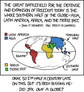
 http://xkcd.com/753/
{Not that the non-JFKs among us are immune from this sort of thing. In the US alone:
+Large portions of West Virginia are actually east of much of Virginia, and some parts of Virginia are west-er than any part of "West" Virginia.
+Spartanburg, South Carolina is north of Wilmington, NORTH Carolina.
+The East River flows south as it makes its way through New York City, and the easternmost point in the continental US is called, what else, West Quoddy Head.
+South Bend is in extreme northern Indiana, West Bend a long way from anything we might call "western" Wisconsin, and for the fun of it I'll throw in the fact that Jo Daviess County in the northwestern corner of Illinois is traditionally lumped in with Carbondale, Decatur, and Cairo as part of the region known as "Downstate."
Okay, okay, I know there are reasons for all these names, North Carolina is (mostly) north of South Carolina, the East River is east (of Manhattan), Downstate Illinois basically means not-Chicago, yeah, yeah, yeah, what-ever. I still say we need truth in advertising. What's west should never be east, and what's down should not be up, and it should be possible to distinguish north from south easily and quickly and confidently. The spatial reasoning skills of our youngsters are at stake! Won't someone please think of the children?}

No comments:
Post a Comment